Strikes and Vital Sites in Dahiya: Health and Educational Facilities
Throughout the Israeli assault on Lebanon and as the ceasefire was being negotiated, the Beirut Urban Lab was in the process of documenting how the assault was deliberately targeting all forms of life and causing forced displacement across localities. As part of this effort, the BUL was mapping the impacts of the Israeli strikes on vital sites: health and educational facilities, markets and commercial strips, as well as religious and cultural buildings.
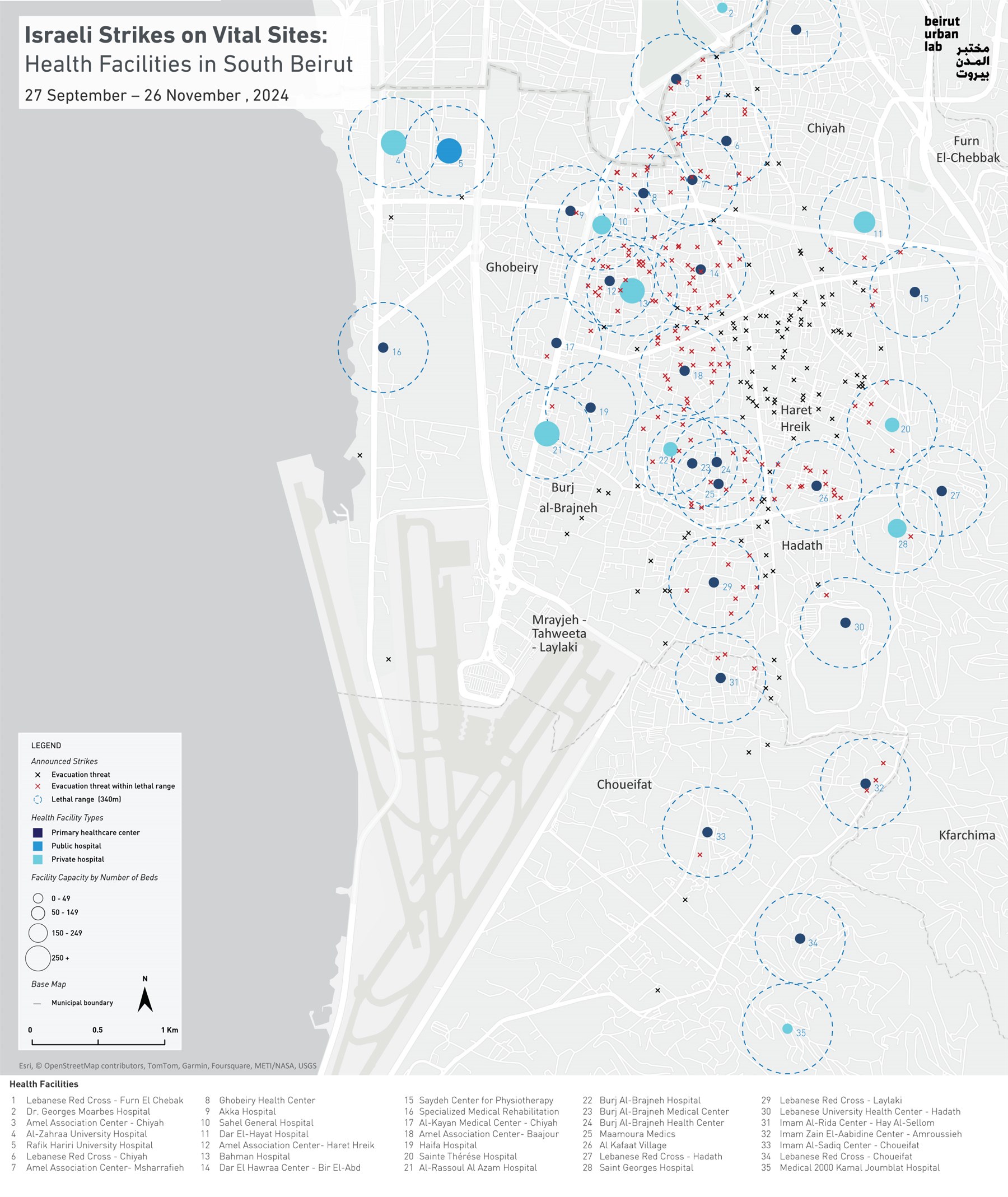
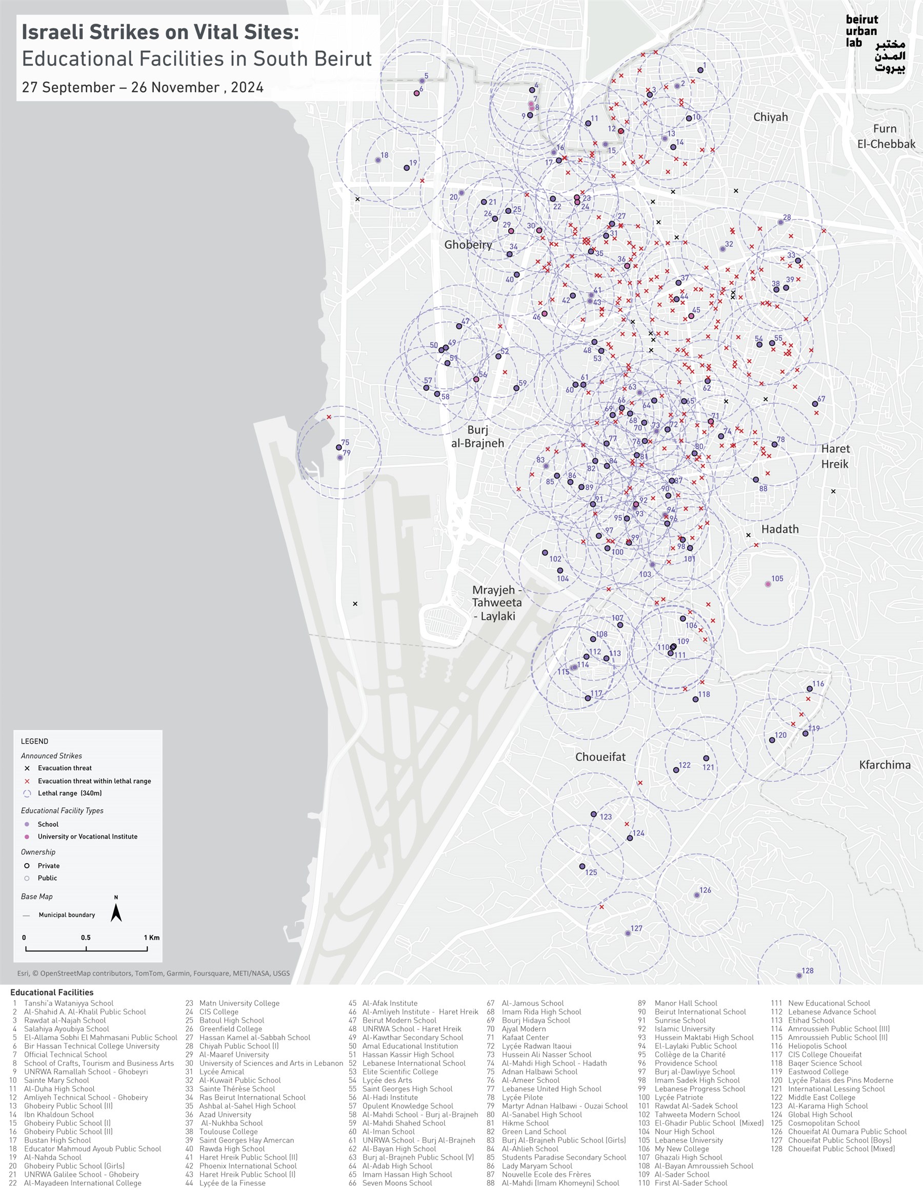
These two maps, “Strikes and Vital Sites in Dahiya: Health Facilities/Educational Facilities,” identify the 279 announced strikes on South Beirut over 61 days (between 27 September and 26 November 2024). The map does not include the additional unannounced strikes.
The maps show that over half of the announced strikes on south Beirut have hit the vicinity of over 75% of the district’s health facilities, and that over 90% of the announced strikes were in the vicinity of close to 80% of the districts’ educational facilities.
Dahiya’s neighborhoods vary significantly in density, building age and building condition, including old, dense and tight-knit urban fabric in Bourj Al-Brajneh and Mrayjeh for instance, where the strikes’ impacts were likely more lethal than strikes in the newer, less dense and relatively more regular urban fabric of Haret Hreik or Sainte-Therese for instance. Yet, Dahiya’s urban structure is overall quite dense and strikes on any of its buildings had dire impacts on their surroundings, including the numerous vital sites that are adjacent to them.
×
Health Facilities
×

×
![]()
The map features 35 health facilities spread throughout South Beirut’s neighborhoods, based on the listing featured on the Ministry of Public Health (MoPH) website in addition to BUL’s desk research. Of these, 27 have received strikes in their close vicinity.
These 27 health facilities can be divided in two categories: 7 private hospitals, 18 primary healthcare centers (PHCs; managed by the Lebanese Red Cross or by local NGOs, affiliated to the MoPH), and 2 other healthcare centers. PHCs are neighborhood facilities that provide emergency and primary care to the residents, in addition to clinical services related to pediatrics, obstetrics-gynecology, physiotherapy, dialysis and others. They operate as community centers in the neighborhood, caring for the sick, elderly, women and children—most of whom living in precarious condition.
The impact of strikes obviously goes beyond the building they target, and they cause destruction and damage in a wide radius, depending on the type and size of munition used. BUL opted to adopt a “lethal range” (*) of 340 meters to count the number of strikes that have hit the vicinity of health facilities.
BUL’s map demonstrates that over half of the announced strikes on Dahiya (142 out of 279) have hit the vicinity of 77% of the district’s health facilities (27 out of 35). These include:
- Seven hospitals; Bahman private Hospital, one of the largest hospitals in Dahiya, received 21 strikes in its vicinity; Sahel General Hospital, 9 strikes; Bourj Al-Brajneh Hospital, 8 strikes; Sainte-Therese Hospital, 5 strikes; Al-Hayat Hospital, 2 strikes; Al-Rassoul al-Aazam and Saint-Georges Hospitals, 1 strike.
- Eighteen PHCs; Half of the PHCs have received over 10 strikes in their vicinity. Two of those have received over 20 strikes: the Amel Association, a secular NGO that manages four PHCs in Dahiya, received 23 strikes around its center in Baajour (Bourj Al-Brajneh) and 20 around its Haret Hreik center, while Dar Al-Hawraa center in Bir Al-Abed received 22 strikes in its vicinity. The Lebanese Red Cross in Chiyah and Laylaki received 10 and 9 strikes in their vicinity.
The Legal Agenda condemns attacks on hospitals and medical personnel as war crimes, citing the Protocols of the Geneva Convention that states that hospitals enjoy special protection extending to all wounded, irrespective if they are combatants or not. The Legal Agenda further clarifies that targeting hospitals violates the rules of war by threatening the sick and the injured of the protection guaranteed by the rules of war.
×
Educational Facilities
×

×
![]()
The map features 128 public and private educational facilities, including schools, universities and vocational institutes. Of the 279 announced strikes, 91% (261) were in the vicinity of 78% of the educational facilities in South Beirut (101 out of 128).
All the educational facilities in Bourj Al-Brajneh municipal territory (24), in Haret Hreik (16) and in Mrayjeh-Tahweeta-Laylaki (16) were hit in their vicinity; and half of them in Ghobeyri (18 out of 36).
Out of the 24 public and 90 private schools, 90 were within the lethal range of announced strikes (78%). The most threatened were the private schools Lycée Amical, Ashbal al-Sahel, Lycée de la Finesse and Hassan Kamel al-Sabbah school, all in Haret Hreik, with over 20 strikes in their vicinity. Most of the 14 universities and the vocational universities received announced strikes in their surroundings: Azad University in Haret Hreik received 27 strikes; Al-Afak Institute, also in Haret Hreik, 24 strikes; Kafaat Institute, 16 strikes; Amliyeh Institute in Ghobeyri, 13 strikes; University of Sciences and Arts in Lebanon, 11 strikes. Sixteen educational institutions were hit by over 15 strikes in the lethal range identified. One-third (38) received over 10 announced strikes in their vicinity. Fourteen of those were located in Haret Hreik and 14 across Mrayjeh-Tahweeta-Laylaki and Hadath.
The bombings on Dahiya not only destroyed individual buildings, homes, businesses and livelihoods, but directly damaged healthcare and educational facilities, further demonstrating how the Israeli assault on Lebanon was deliberately damaging vital sites, annihilating forms of life and forcefully displacing people.
(*) The term “lethal range” or “lethal radius” is used to refer to the area of exposure to injury or killing around a bombed target, with this radius proportionally increasing with heavier munition. BUL adopted the 340m range relying on this CNN article that discussed the impacts of Israeli bombing on the health sector in Lebanon. The UN developed a “blast damage estimation” calculator that approximates injury and fatality ranges and damages to brick structures but that requires knowledge of the explosive type and charge size. In a recent study, The National documented that the explosives used during the Israeli assault on Lebanon were MK83 and MK84 missiles (1,000 and 2,000lb munitions).
×
Project lead: Mona Harb
Project Coordinator: Antonia Maria Bahna
Visualization team: Karim Chaltaf, Abir Cheaitly, Ahmad Gharbieh
GIS Database Management: Jawad Choueib, Shareef Tarhini
Data collection: Jimmy Matar
Translation: Zeina El Hoss
Funding Agency: AUB-OGC
Project Coordinator: Antonia Maria Bahna
Visualization team: Karim Chaltaf, Abir Cheaitly, Ahmad Gharbieh
GIS Database Management: Jawad Choueib, Shareef Tarhini
Data collection: Jimmy Matar
Translation: Zeina El Hoss
Funding Agency: AUB-OGC