Despite the declared ceasefire of April 16, 2026, Israel continues to unleash widespread destruction across Lebanon, with South Lebanon bearing the brunt of the assault. In an effort to raise awareness, foster accountability, and support recovery, the Beirut Urban Lab (BUL) publishes today a first mapping focused on the city of Nabatieh and its surrounding region. This mapping is the outcome of several months of careful documentation and analysis conducted by BUL’s team. It constitutes an initial installment in what we envision as a sustained effort to produce accurate, georeferenced, and detailed socio-spatial layers of South Lebanon—layers that can serve as a foundation for archiving and, ultimately, recovery (Al Harithy et al., 2025).
The mapping of Nabatieh and its region is part of a broader endeavor to document and analyze the built and natural layers of South Lebanon’s wounded geographies—our modest yet deliberate step to resist the foreclosure of the future that ongoing violence seeks to impose. Through this work, we seek to articulate an in-depth understanding of both built and natural environments—heritage sites, social infrastructures, and shared open spaces—as expressions of deeply rooted communities whose presence and continuity we aim to support.
At the same time, we document the impacts of successive waves of violence that continue to devastate these areas—recording loss, tracing destruction, and bearing witness to the crimes inflicted on both people and land. Ultimately, we approach this archival effort as a space for collaborative exchange and a tool for thinking forward: toward recovery and reconstruction, and toward a practice of planning that persists amid violence—one that learns from wounded communities and works to sustain the possibility of living together, and better, on ancestral land.
Context: South Lebanon
Since the early 1920s, South Lebanon has been a territorial and hydrological frontier of the Zionist expansionist colonial ambitions that were imposed on Palestine (Foster 2026, Khalidi 2020). Subjected to regular violence, repeated incursions, and intermittent occupations, including the continued imposition of an occupation zone between 1978 and 2000. Since October 7, 2023, South Lebanon has been subjected to severe aggression. As we write these lines, Lebanese fighters are defending the grounds against the Israeli Armed Forces’ invasion, while the rest of the country is subjected to continuous forced displacement, harassment by low-flying warplanes and whirring drones, and repeated airstrikes and military attacks.
Nabatieh
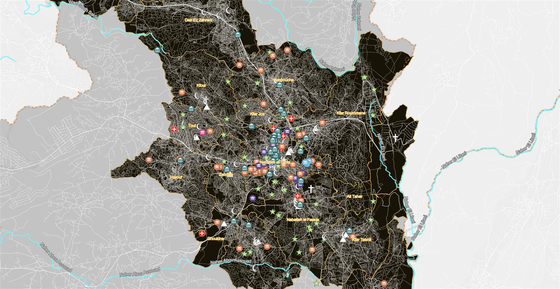
The map we issue today covers the city of Nabatieh and its hinterland. It includes 15 municipal districts spanning 18 cadastral zones, all centered on the city of Nabatieh, which forms the core of this urban area, home to some 80,000 permanent residents. Nabatieh lies 80 km south of Lebanon’s capital, Beirut, and is the administrative center of one of the country’s eight governorates.
Well before Lebanon’s independence (1943), Nabatieh played a prominent role in commerce, culture, and religious scholarship in Jabal Amil, a region that spans today's national borders and extends across South Lebanon, the occupied Golan (al-Juwlan), and the Palestinian Galilee (al-Jaleel). This position was acknowledged in Lebanon’s 2009 National Master Plan. It translated into an array of large-scale development projects, including electricity and sewer infrastructure, roads, government facilities, and large educational and healthcare facilities. Consequently, the city and its region continued to attract populations from surrounding areas as well as expatriate investments, all of which fueled a vibrant regional economy of services (e.g., education, healthcare, banks), small-scale industries (e.g., car repair, construction, furniture manufacturing, machinery, workshops), and diverse commercial activities (e.g., general trade, leisure facilities, tourism), as well as primary and secondary homes perhaps best measured through the number of building permits issued in this region between 2000 and 2023 (see reference NBNED).
Nabatieh’s heritage combines layers of natural and built landscape that form the hallmark of South Lebanon’s ecology, where villages historically merged within the undulating topography of hills and valleys. Here, villages historically formed around a tight-knit core of stone houses and narrow alleys surrounded by agricultural fields, such as Sahel el Maydaneh where one of the Litani River’s tributaries runs through.
Until the recent Israeli assault in March 2026, Nabatieh’s historic core retained much of its tightly knit socio-spatial fabric. However, a ring of dense urbanization had replaced most of the historical suburban garden houses where prosperous families had moved during the mid-19th century. Aside from the surviving architectural elements, the significance of Nabatieh’s urban heritage lies in the dynamic relationships between urban spaces, collective memory, and lived practices. Indeed, the city’s cultural and economic heart is anchored in its souks, its centuries-old weekly Monday itinerant market, its public open spaces, its religious landmarks, and the surrounding hilltops, all of which structure patterns of social interaction and reinforce a shared sense of place.
At the regional scale, Nabatieh’s growing regional role translated into dozens of lot subdivision projects that rapidly transformed the terraced orchards landscapes (e.g., olive, carob, citrus, pomegranate) and the fields of temporary crops (e.g., tobacco, wheat) into a grid that facilitates building development. Since the 1980s, the natural and built environments have blurred as sprawling urbanization has extended into surrounding villages, now forming a continuous urban agglomeration.
In the context of understanding the unfolding effects of war displacement since October 2023, and seeking avenues for recovery, the selection of the city as a case study was both strategic and urgent: Nabatieh sustained major damage, received large numbers of displaced populations, yet it remains accessible as a site where documentation is possible. The city also holds a special place in our lab, as several team members grew up in Nabatieh and its surroundings and regularly visit their families, infusing this project with immediate meaning.
Israel’s war machine and, sadly, some of its echoes in Lebanon’s political scene, tend to homogenize political life across South Lebanon -including Nabatieh- and limit its representation and voice to Shia Muslim sectarian political parties, namely Amal and Hezbollah. Our reading of the region nonetheless reveals a richer dynamic at play. To be sure, Hezbollah’s role in military resistance, as well as its sustenance of an ideological social life for decades, has given it substantial political support, as has Amal, though primarily through its ability to control access to state institutions and employment (Harb 2010). Additionally, Nabatieh is the cradle of Shiism, with strong regional connections to Iraq (Najaf) and Iran (Qum), and a substantial following of Shia clerical authorities (marja’iyya), reflected in the active role of several local organizations including al-Nadi al-Husseini. In the period following the 2024 cease-fire, the latter spearheaded reconstruction efforts in the historic souq after the 2024 war and launched several urban initiatives in the city (Darwish, 2026). The diversity of the population is not lost on those familiar with this region of the country, where 2019 saw vibrant protests and demands for national transformation, well in line with a long legacy of political organizing, notably by leftist labor organizations and resistance movements, against Israeli incursions dating back decades.
Nabatieh at the Frontiers of Occupation and Liberation
The location of Nabatieh, immediately North of the Litani River, has played a critical role in its historic and contemporary transformations. During the 22 years in which Israel and its proxies imposed a continued occupation of South Lebanon (1978-2000), Nabatieh’s position immediately outside the zones of continued Israeli occupation between 1978 and 2000 made it an accessible refuge for the populations of the surrounding Israeli-occupied towns and villages. Consequently, many chose to settle in the city, either temporarily or permanently, remaining in close proximity to their occupied towns of origin. Following liberation in May 2000, Nabatieh grew considerably, becoming a regional hub of social and economic activity.
Nabatieh’s frontal position was revived after October 2023, as the city absorbed several waves of population displacements as villagers fled Israel’s incessant violence across South Lebanon. During this period, Nabatieh’s building development was fueled by commercial and residential projects that responded to growing demand.
Conversely, Nabatieh itself was subjected to multiple rounds of fire, particularly as of September 2024. Thus, the city suffered from the targeted erasure of its main municipal building, its old historic markets (the souks), and the surrounding historic fabric, including numerous culturally significant (e.g., the mansions of Al Fadel and Al Chahine families) and religious buildings (e.g., a historic mosque in Kfartebnit), in addition to thousands of housing units. The size of the loss is daunting: Since October 8, 2023, the National Council for Scientific Research in Lebanon (CNRS-L) has counted about 100,000 housing units damaged or destroyed in the Nabatieh governorate, a region that extends beyond the study area.
The position of Nabatieh as both refuge and target made it a critical space to map and analyze, as a means to both unravel the multiple forces of planning, war, displacement, and economic investment that went into its production and lay the groundwork for a possible reconstruction strategy. In doing so, the Beirut Urban Lab’s team understands well that war is far from over. Israeli belligerence, as manifested in daily raids across the South since the November 2024 cease-fire, in the surge of destruction in March 2026, and in the almost daily speeches of Israeli government and army officials, some of whom recurrently declare the intent to expand Israel’s territory into Lebanon, leaves little room to hope that these assaults will end soon. Nonetheless, the team believes that planning needs to unfold during wartime, accompany the dynamic reorganization of the territory, and support populations in their quest to remain in place, rebuild homes, and make a living on their ancestral lands.
The Basemap: A Note on Methodology
Building a basemap:
In the absence of a unified official map of the study area, the team relied on its previous experience in building the first detailed georeferenced basemap for the city of Beirut (see the Beirut Built Environment Database) to produce the map of Nabatieh. To build an accurate basemap, the team consolidated several spatial datasets and layers obtained from public institutions and other official sources with high-resolution satellite imagery. These layers include:
1. Existing built-up fabric and road network layers were produced using OpenStreetMap (OSM), CNRS-L maps, and a satellite image from December 2024.
2. Administrative and cadastral layers were produced by digitizing integrating existing cadastral maps. The absence of final, publicly sanctioned property delineations in several cadastral zones meant that property boundaries had to be redrawn to match the building and natural fabrics and to correct discrepancies. In some cases, these discrepancies remain unresolved and are visible on the published maps until final surveys are issued by Lebanon’s cadastral agencies.
3. Land use and land cover data were incorporated using datasets from the CNRS-L. The team consolidated the original classification system into a simpler set of categories to improve clarity and legibility.
4. Landmarks and facilities were identified and georeferenced based on the following sources:
a. Public records and lists of public and private healthcare and educational institutions
b. Google Maps and Open Street Map (OSM) to identify 1) Public Institutions, 2) Religious facilities, 3) Leisure, 4) Public gardens and open spaces, and 5) Other notable landmarks
5. The heritage layer consolidates multiple data sources from the Directorate General of Antiquities (DGA) and the NGO Biladi. In addition, places of socio-cultural significance in Nabatieh Tahta, such as the souq and public open are highlighted.
Moving Forward
Despite a declared ceasefire that went into effect on April 17, 2026, South Lebanon continues to be occupied and bombed. Indeed, the decrease in the number of airstrikes has been coupled by the systematic destruction of villages by Israeli land forces: The Israeli army and media have bragged about this destruction by releasing before/after images of destroyed villages while journalists on the ground have reported private contractors being escorted by the Israeli army to bulldoze and raze homes and agricultural fields in the South. In this context, the work of mapping/archiving is a practice to counter erasure, denounce war crimes, shape the space for collective and deliberative remembrance, and expand the imaginary of the non-violent futures to which we remain committed.
References
Al-Harithy, H., Bazzi, M., & Yassine, B. (2025). Tracking the urbicide in Gaza: Reflections on framing and methods. In G. Ciotoli (Ed.), War is (not) over: Destruction and reconstruction in the urban theaters of war, 1945–2025. Campisano Editore. https://beiruturbanlab.com/en/Details/2032/tracking-the-urbicide-in-gaza-reflections-on-framing-and-methods
Darwish, A., et al. (2026). Hybrid governance in crisis: Faith-based urbanism and the reconstruction of Nabatieh (MUPP thesis, American University of Beirut).
Foster, Z. (2026). Palestine before Zionism: A golden age? Palestine Nexus. https://palestinenexus.com/articles/palestine-before-zionism
Harb, M. (2010). Le Hezbollah à Beyrouth (1985–2005): De la banlieue à la ville. Karthala.
Khalidi, R. (2020). The hundred years’ war on Palestine: A history of settler colonialism and resistance, 1917–2017. Metropolitan Books.