The Beirut Urban Observatory
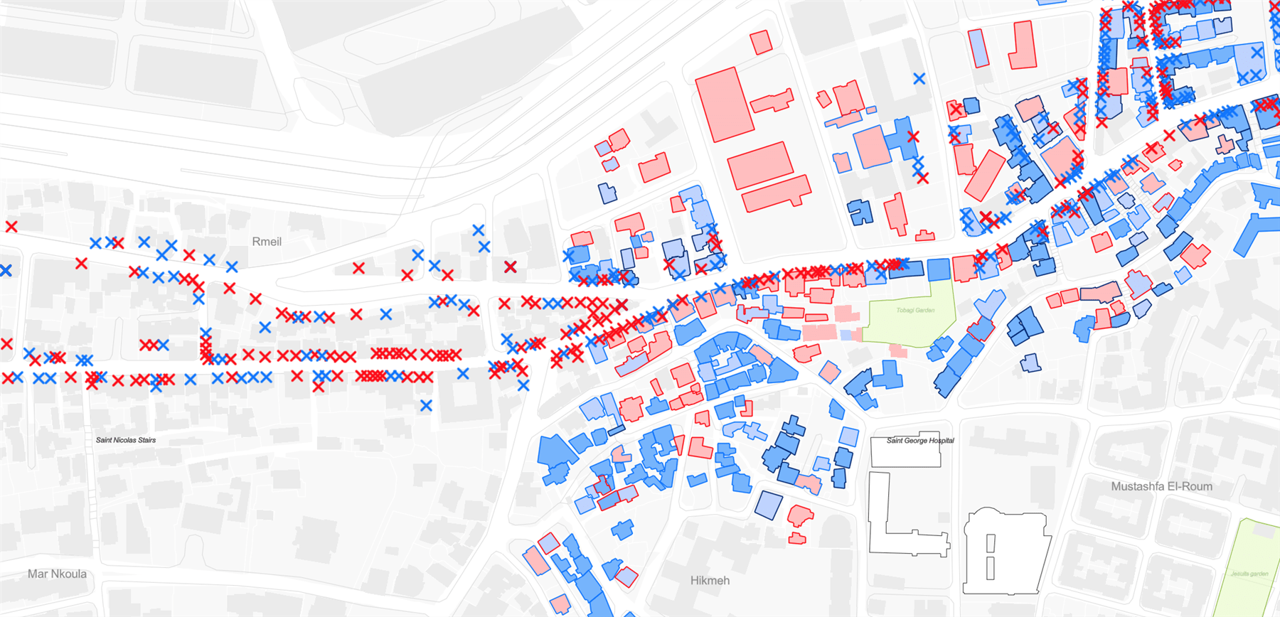
Map 1 - Return of Life: Gemmayze, Mar Mikhail and Hekmeh: This map assesses preliminary return to life to the blast affected neighborhoods looking at the external condition of buildings and their occupancy rates on one side, and by identifying the opening or closure of businesses in selected commercial streets on the other.
The Beirut Urban Observatory is a platform of geolocalized urban data informing ongoing post-blast recovery efforts.
×
The Beirut Urban Lab launched the Beirut Urban Observatory in August 2021, one year after the Port Blast. As a platform of shared geolocalized data, the Observatory builds on the Beirut Built Environment Database (BBED). It aims at facilitating coordination among multiple stakeholders, producing and disseminating maps and visual data, informing city dwellers and key actors about ongoing repair and recovery processes, and supporting an integrated and inclusive framework of urban recovery. The Beirut Urban Observatory is an initiative that engages multiple actors (INGOs, NGOs, universities, professionals, think tanks, research centers, activists and others).
The Observatory currently features six main components: (i) damage assessments conducted in the aftermath of the blast by the Order of Engineers and Architects (OEA); (ii) a baseline data set, synthesizing several layers from the BBED featuring key urban trends in the pre-blast city; (iii) an advocacy project that seeks to initiate a green path in lieu of the planned Fouad Boutros highway (Al-Masar Al-Akhdar), in continuity of the activists’ campaign to stop its construction; (iv) an overview of open spaces and community-based projects in the neighborhoods affected by the blast (see Map 2); (v) a socio-economic assessment of Karantina that is informing a participatory planning intervention in the neighborhood’s open spaces (see Map 3); and (vi) indicators of return to life in Gemmayzeh, Mar Mikhail and Hikmeh, focusing on local economy and status of repair and inhabitation (see Map 1).
The Observatory currently features six main components: (i) damage assessments conducted in the aftermath of the blast by the Order of Engineers and Architects (OEA); (ii) a baseline data set, synthesizing several layers from the BBED featuring key urban trends in the pre-blast city; (iii) an advocacy project that seeks to initiate a green path in lieu of the planned Fouad Boutros highway (Al-Masar Al-Akhdar), in continuity of the activists’ campaign to stop its construction; (iv) an overview of open spaces and community-based projects in the neighborhoods affected by the blast (see Map 2); (v) a socio-economic assessment of Karantina that is informing a participatory planning intervention in the neighborhood’s open spaces (see Map 3); and (vi) indicators of return to life in Gemmayzeh, Mar Mikhail and Hikmeh, focusing on local economy and status of repair and inhabitation (see Map 1).
×
Each component features mappings and data visualizations that incorporate a series of navigable layers and propose correlations of particular datasets. Across the Observatory, the data can be explored through a variety of navigational experiences and media that range from diagrammatic representation to photographic documentation.
×
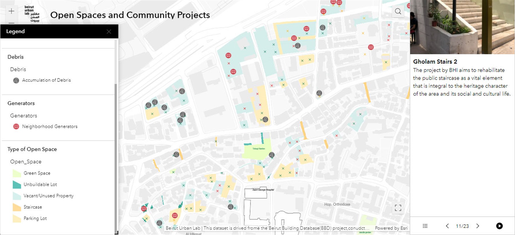

Map 2 - Open Spaces and Community Support Projects: This dataset displays publicly and privately owned vacant lots and gives information about their conditions. The map also locates a first set of community support projects led by CSOs, NGOs and INGOs.
×
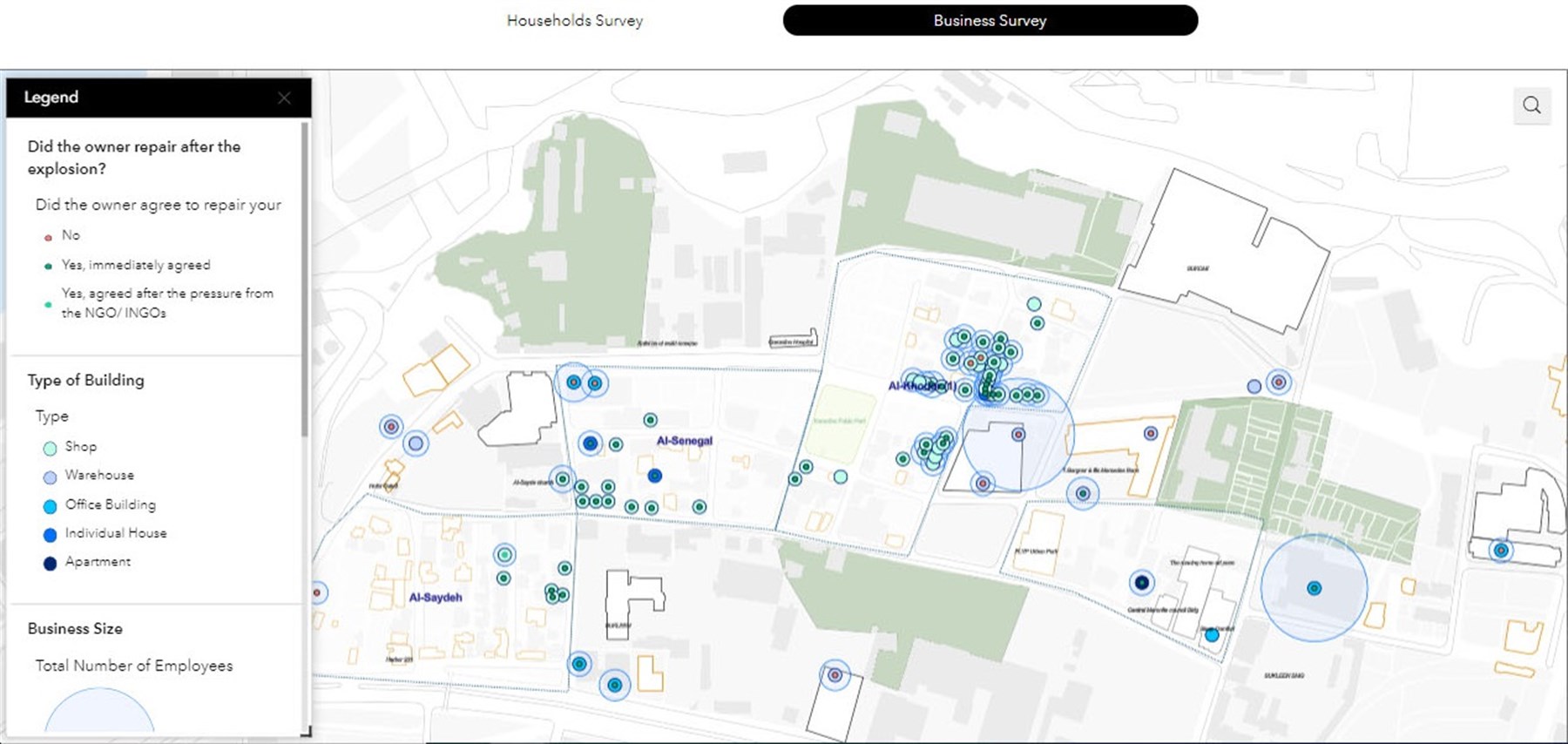
Map 3 - Socio-economic Profile of Karantina: In-depth surveys were conducted by the Karantina recovery research team and trained local researchers that included socio-economic profiling of households, businesses, a damage assessment, aid and relief efforts and mapping of the socio-spatial practices.
×
In the coming months, further outputs related to recovery actors and governance, housing vulnerability, modalities of repairs, public space and the local economy are scheduled to be added to the Observatory.
The Beirut Urban Observatory is funded by the International Development Research Centre (IDRC) and the Fondation de France. It runs in collaboration with more than twenty local and international NGOs, public institutions and professional syndicates, and research and academic centers. In the absence of effective public institutions leading reconstruction efforts, such platforms represent a critical ingredient in contributing to the coordination of the various actions on the ground and in facilitating information access and data exchange.
The Beirut Urban Observatory is funded by the International Development Research Centre (IDRC) and the Fondation de France. It runs in collaboration with more than twenty local and international NGOs, public institutions and professional syndicates, and research and academic centers. In the absence of effective public institutions leading reconstruction efforts, such platforms represent a critical ingredient in contributing to the coordination of the various actions on the ground and in facilitating information access and data exchange.