Mapping One Month of Announced Strikes in South Beirut (September 27 - November 4, 2024)

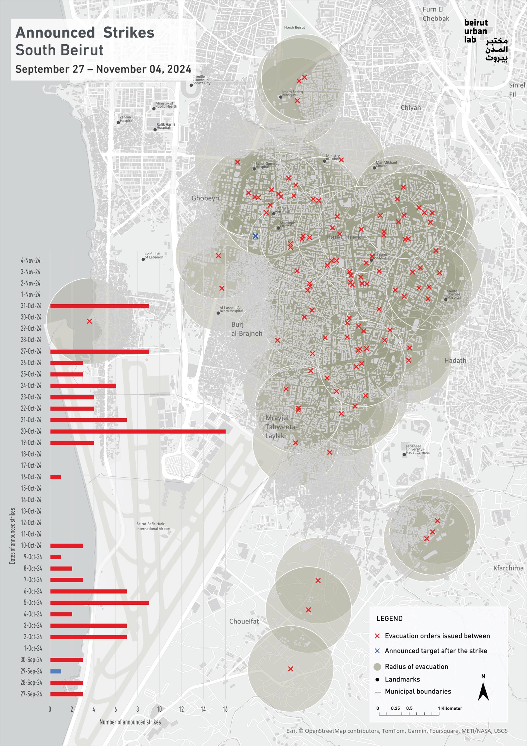
Since September 27, Israel’s war on Lebanon has expanded its brutal violence to Lebanon’s capital, Beirut, as well as many regions across the country.1 No less than 325 buildings2 have been destroyed south of the city where the radius of devastation (seen in the outlined gray zones) extends over 11.87km2, or more than half the capital’s immediate urbanization perimeter.3
The map tracks the forced “evacuation orders” issued by the Israeli Army warning the civilian populations of South Beirut between September 27 and November 4, 2024. Each order delineates a building or more as well as a number of urban blocks, where one or several impending strikes are planned. These orders pretend to act as warnings. They are published in Arabic a few minutes to an hour ahead of the strike(s) on the “X” social media platform (formerly known as Twitter), mostly during the late evening hours. The orders instruct residents to immediately evacuate the premises within a radius of 500m (0.311 miles) from the targeted cluster of buildings (1-4), framed in red on an aerial photo clipped with specific landmarks in the neighborhood. The forced order is accompanied by a text listing the names of the neighborhoods targeted and justifying the forthcoming attacks in relation to their proximity to “facilities related to Hizballah.”
No less than 109 announced strikes extending over 160 buildings were counted between September 27 and November 4, 2024, and they constitute less than half the total number of destroyed buildings in this part of the city.4 Indeed, not all strikes are accompanied by an evacuation order. Still, the geography of the red crosses reflects the scale and intensity of the violence throughout South Beirut, all the way to the campus of the Lebanese University in Hadath, the borders of Lebanon’s International Airport’s runway, and the industrial areas of Choueifat. One blue mark indicates the single post-strike announcement made following the assassination of the secretary general of Hizballah, Hassan Nasrallah on September 27.
We focus on the mapping on South Beirut where the municipal districts of Ghobeyri, Haret Hreik, Burj Al-Brajneh, Mrayjeh-Tahweeta-Laylaki and Hadath have borne the brunt of the airstrikes during the past month. Each of these districts has been subjected to over 60 strikes. These districts are within the area popularly referred to as Dahiya, where Israel’s multiple and repeated aggression since September 27 has displaced hundreds of thousands of inhabitants and destroyed multi-story residential and commercial buildings.
By reducing Dahiya to a political stronghold and associating the term “stronghold” to the name of Hizballah, a political party with ministers in Lebanon’s government and parliamentary representation in Lebanon’s Assembly in addition to its strong (non-state) military power, Israel (and much of the Western media) conflates political support, allegiance, and armed force—hence declaring it legitimate to target civilians because of (assumed) political preferences. In doing so, Israel denies the reality of multiple and diverse districts, composed of dozens of neighborhoods rich with an urban, social, economic and political history that precedes Hizballah by decades. The bombing is akin to an urbicide that is erasing an entire urban fabric, the palimpsest of socio-spatial practices and the embodiment of collective memory. Finally, the “stronghold” qualifier occults the historical conditions where the use of armed resistance was endorsed as a mode of struggle against the Israeli armed forces that invaded South Lebanon repeatedly, occupied its territories, violated its airspace daily, and inflicted immense damage on its populations.
The forced evacuation orders are far from acting as a genuine call to protect civilians. Instead, we read them as part of Israel’s strategy to manufacture consent for the incoming strikes, legitimizing the bombings by claiming the presence of a so-called “terrorist” threat. These orders further serve as an integral component of Israel’s strategy at mounting the people of Lebanon against Hizballah, discounting the socio-political and urban realities of a society that has come to rely on this party for all of its social needs. This strategy finally enables the claim that the air raids only target “Hizballah facilities”, while in practice the damage extends to an entire civilian infrastructure.
To residents, the forced evacuation orders constitute an integral element of the terror apparatus deployed by the Israeli army, a key ingredient of the psychological warfare waged against them, in addition to being precursors of announced destruction and killing. They terrorize numerous city households who await the strikes in deep fear, sometimes sleeping in shifts to take turn monitoring social media for possible warnings. These orders work along with the perpetual whirring of surveillance drones, the robot-calls that announce impending bomb attacks (often erroneously), the targeted drone attacks that extend to every corner of the country, along with the lethally violent daily air and land bombings that have wiped out entire villages in the south and east of the country.
The Beirut Urban Lab continues to monitor the strikes on Beirut, develop further base maps, and extend our documentation to visualize and denounce the size and intensity of Israel’s aggression. The hope remains that this work will further contribute to hold Israel accountable in front of international courts and, looking ahead, to contribute to a just recovery.
1 The turning point for the increased violence may be better placed at September 17, the date of the infamous pagers’ attacks.
2 We rely on the work of the Conflict Ecology Lab for the numbers of demolished buildings.
3 To give an idea of the scale, we note that this radius is five times larger than the main radius affected during the 2006 war.
4 See fn. 2.