Mapping Israeli Announced Strikes on Lebanon
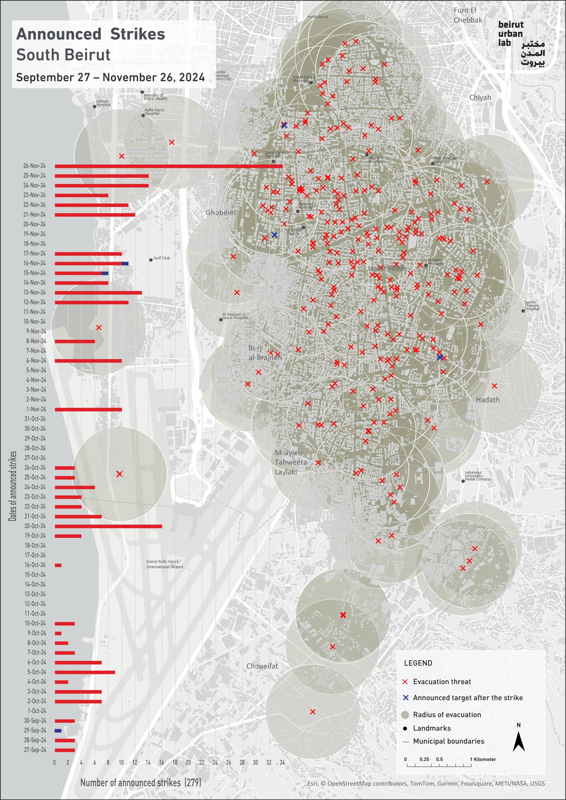
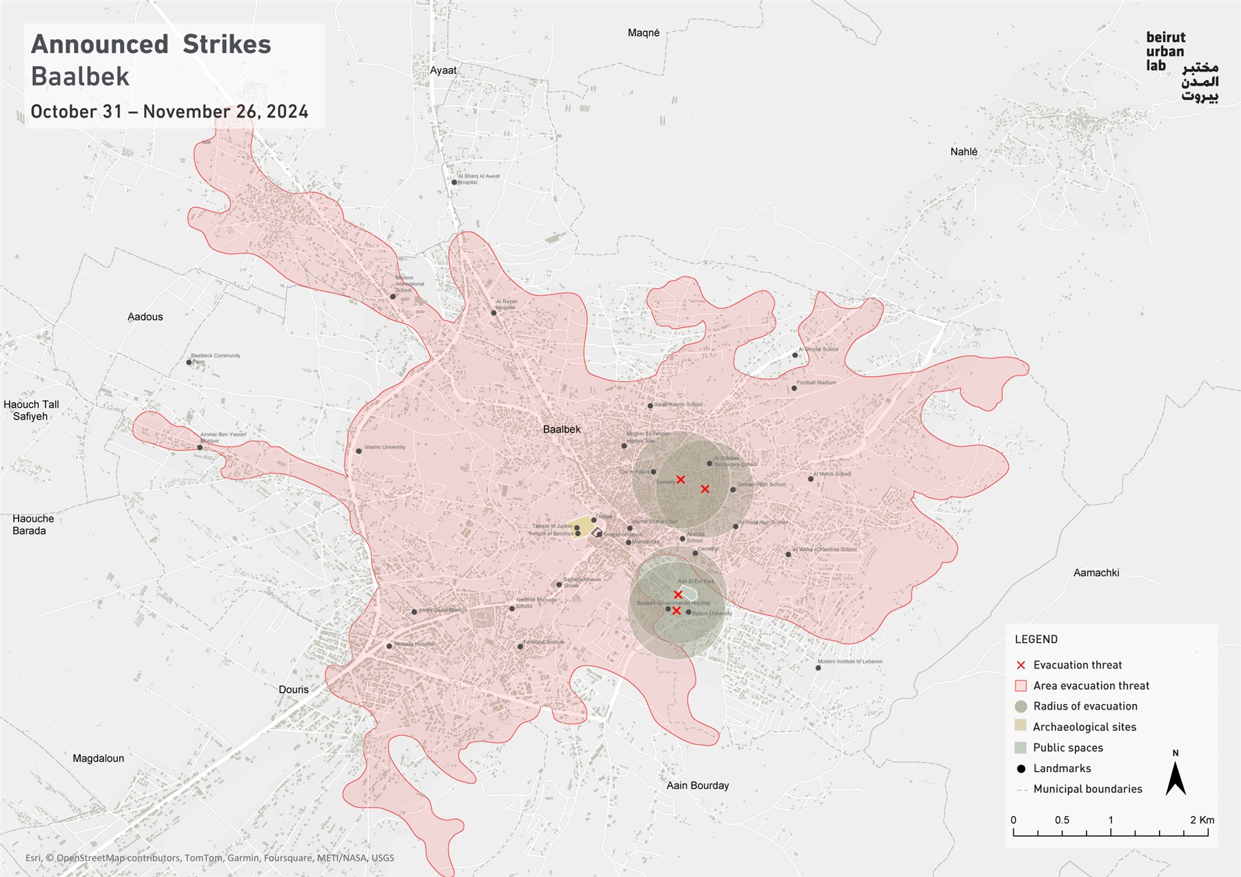
Since September 2024, the Beirut Urban Lab has mapped the Israeli army’s evacuation threats in South Beirut. Published on the X platform, the threats warn civilian populations of an imminent assault. Through this mapping, the Lab provides a record of the distribution, location, and intensity of the announced airstrikes. Similar mappings covering the city of Tyre (South Lebanon) and additional localities and regions targeted by Israeli violence are being added as they are produced.
Dahiya

Dahiya is often simplistically presented as a “Shia ghetto” or “Hizballah’s stronghold,” dehumanizing and sectarianizing its 700,000 dwellers, while weaponizing its vibrant and diverse socio-economic fabric. The spatial production of Dahiya as a contested socio-political territory in relation to Hizballah and other stakeholders has a complex history that is summarized here.
Dahiya’s territory amounts to 15.4 sq.km (municipal Beirut is 21.3 sq.km). It incorporates the four municipalities of Ghobeyri, Haret-Hreik, Bourj al-Brajneh and Mrayjeh-Laylaki-Tahweeta, in addition to sections of the municipalities of Chiyah, Hadath and Choueifat. These municipal territories include dozens of neighborhoods which, as any ordinary neighborhood in other districts of Greater Beirut, are rich with a pulsating and dense urban life, centered on homes, street markets, bakeries, shops, bookstores, small and medium enterprises, restaurants, cafés, mosques, schools, universities, health facilities, sports facilities, government buildings, as well as public and open spaces.
Since 27 September 2024, Dahiya has been the target of 279 Israeli announced strikes, demolishing at least 361 buildings, averaging about 4.5 strikes/day.1 On the most violent days during November, Dahiya was struck with over 10 strikes daily. The most intensified attacks occurred on the night of the cease-fire when 34 announced strikes targeted Dahiya. Haret Hreik is the most hit municipal territory, with 128 destroyed buildings, followed by Hadath (67 buildings) and Ghobeiry (62 buildings). Announced strikes are accompanied by additional unannounced strikes that are not featured in the map.
The Israeli assault on South Beirut’s neighborhoods is implementing in all impunity its “Dahiya doctrine” (introduced during the 2006 war on Lebanon), annihilating the possibility of life in the locality and causing durable forced displacement. According to Martin Coward’s work, this assault is akin to urbicide, which is the deliberate destruction of buildings and infrastructure in ways that also disrupt social, economic and cultural networks, displace populations, and erase the collective memory associated to place.
1 The extent of the damage is more extensive when unannounced strikes are taken into account. According to the CRNS, between September 27 and November 21, 2024, a total of 358 attacks (both announced and unannounced strikes) were recorded in Dahiya, affecting 1,821 buildings to varying degrees of damage.
Tyre
.jpg)
Between October 17 and November 28, the city of Tyre and its immediate vicinities were subjected to relentless violence. The city's historic core was largely emptied of its population, receiving 10 of the 27 evacuation threats that cover 50% of the city’s total residential fabric.1 East of Tyre, the neighborhood of Hosh may have received the most severe and systematic bombardments and dozens of recently developed multi-story residential apartment buildings were brought to the ground.
All in all, 29% of buildings in Tyre and its immediate vicinities, amounting to roughly 4,500 buildings, have received direct evacuation threats, followed by brutal airstrikes that severely damaged the city's fabric.
1 According to the UN Habitat report “Lebanon-Building Destruction and Debris Quantities Assessment: South and Nabatiyeh Governorates”, 3,498 buildings were totally and partially destroyed.
Baalbek

Despite this wealthy cultural pedigree, the region of Baalbek is notorious for state neglect and the consequent poverty of its populations. Since the mid-1980s, Baalbek has also been widely associated with the political presence of Hizballah, and many of the party’s personalities draw their roots in its region.
More than any previous war, Baalbek fell under severe Israeli fire during its latest assault on Lebanon. Not only did the city and its temple fall within the perimeter of the evacuation threats of the Israeli army, but so did the surrounding agricultural fields within a wider area of 24.2 km2. In addition, several targeted evacuation threats were issued in close proximity to the main temple of Jupiter and the temple of Mercury. The images of the smoke coming out of the city with the background of these temples elicited a unanimous outcry across Lebanon’s populations who expressed severe fears about long term damage to the best-known national symbol of the country.
Project Coordinator: Antonia Maria Bahna
Visualization team: Karim Chaltaf, Abir Cheaitly
GIS Database Management: Jawad Choueib, Shareef Tarhini
Translation: Zeina El Hoss
Funding Agency: AUB-OGC